Tyrone, Georgia
Tyrone, Georgia | |
|---|---|
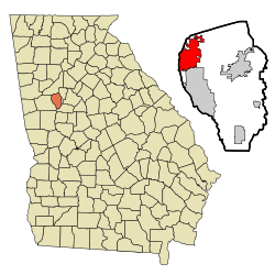
 Location in Fayette County and the state of Georgia | |
| Coordinates: 33°28′25″N 84°35′28″W / 33.47361°N 84.59111°W | |
| Country | United States |
| State | Georgia |
| County | Fayette |
| Named for | County Tyrone |
| Area | |
| • Total | 12.88 sq mi (33.36 km2) |
| • Land | 12.51 sq mi (32.39 km2) |
| • Water | 0.38 sq mi (0.97 km2) |
| Elevation | 981 ft (299 m) |
| Population (2020) | |
| • Total | 7,658 |
| • Density | 612.35/sq mi (236.44/km2) |
| Time zone | UTC-5 (Eastern (EST)) |
| • Summer (DST) | UTC-4 (EDT) |
| ZIP code | 30290 |
| Area code(s) | 770, 678 |
| FIPS code | 13-78044[2] |
| GNIS feature ID | 0324475[3] |
| Major airport | ATL |
| Website | tyrone |
Tyrone is a town in Fayette County, Georgia, United States. The population was 7,658 in 2020. The estimated population in 2018 was 7,388.[4] It is a part of the Atlanta metropolitan area.
History
[edit]The Georgia General Assembly incorporated Tyrone as a town in 1911.[5] The community's name is a transfer from County Tyrone, in Northern Ireland.[6]
Geography
[edit]Tyrone is located in the northwest corner of Fayette County at 33°28′25″N 84°35′28″W / 33.47361°N 84.59111°W (33.473563, -84.591229).[7] It is bordered to the south by Peachtree City, to the west by Coweta County, across Line Creek, and the north by Fulton County.
Georgia State Route 74, the Joel Cowan Parkway, passes through Tyrone, leading north 5 miles (8 km) to Interstate 85 on the south side of Fairburn. Downtown Atlanta is 25 miles (40 km) northeast of Tyrone via SR 74 and I-85.
According to the United States Census Bureau, Tyrone has a total area of 12.9 square miles (33.3 km2), of which 12.5 square miles (32.3 km2) is land and 0.4 square miles (1.0 km2), or 2.94%, is water.[8]
Demographics
[edit]| Census | Pop. | Note | %± |
|---|---|---|---|
| 1930 | 128 | — | |
| 1940 | 118 | −7.8% | |
| 1950 | 156 | 32.2% | |
| 1960 | 124 | −20.5% | |
| 1970 | 131 | 5.6% | |
| 1980 | 1,038 | 692.4% | |
| 1990 | 2,724 | 162.4% | |
| 2000 | 3,916 | 43.8% | |
| 2010 | 6,879 | 75.7% | |
| 2020 | 7,658 | 11.3% | |
| U.S. Decennial Census[9] | |||
| Race | Num. | Perc. |
|---|---|---|
| White (non-Hispanic) | 4,186 | 54.66% |
| Black or African American (non-Hispanic) | 2,357 | 30.78% |
| Native American | 17 | 0.22% |
| Asian | 298 | 3.89% |
| Pacific Islander | 4 | 0.05% |
| Other/mixed | 364 | 4.75% |
| Hispanic or Latino | 432 | 5.64% |
As of the 2020 United States census, there were 7,658 people, 2,506 households, and 2,178 families residing in the town.
Education
[edit]Within the town of Tyrone there are three public schools: Burch Elementary, Flat Rock Middle, and Sandy Creek High School. These three are located in a triangle configuration on the same street (Jenkins Road). Our Lady of Victory Catholic School is located on Kirkley (aka "Kirkly") Road off Highway 74. South of town is Crabapple Elementary School. East of town is Bennett's Mill Middle School.
Notable people
[edit]- Joey Clanton, NASCAR driver
- Calvin Johnson, former NFL wide receiver, Pro Football Hall of Fame inductee
- Brian Branch, NFL safety for the Detroit Lions
- Andrew Gardner, NFL football player, Miami Dolphins
- Kedric Golston, NFL football player, Washington Redskins
- Mike Hilton, NFL football player, Cincinnati Bengals
- Jody Knowles, NASCAR driver
- Morris Robinson, operatic bass, Metropolitan Opera
- Brittany Swann, Miss Georgia USA 2007
References
[edit]- ^ "2020 U.S. Gazetteer Files". United States Census Bureau. Retrieved December 18, 2021.
- ^ "U.S. Census website". United States Census Bureau. Retrieved January 31, 2008.
- ^ "US Board on Geographic Names". United States Geological Survey. October 25, 2007. Retrieved January 31, 2008.
- ^ "Population and Housing Unit Estimates". Retrieved September 1, 2019.
- ^ Acts and Resolutions of the General Assembly. 1911. p. 1604.
- ^ Krakow, Kenneth K. (1975). Georgia Place-Names: Their History and Origins (PDF). Macon, GA: Winship Press. p. 235. ISBN 0-915430-00-2.
- ^ "US Gazetteer files: 2010, 2000, and 1990". United States Census Bureau. February 12, 2011. Retrieved April 23, 2011.
- ^ "Geographic Identifiers: 2010 Census Summary File 1 (G001), Tyrone town, Georgia". American FactFinder. U.S. Census Bureau. Archived from the original on February 13, 2020. Retrieved April 27, 2016.
- ^ "Census of Population and Housing". Census.gov. Retrieved June 4, 2015.
- ^ "Explore Census Data". data.census.gov. Retrieved December 13, 2021.
External links
[edit]- Town of Tyrone official website
- Palmer Family Cemetery historical marker

